
115. James Cook 1728 - 1779
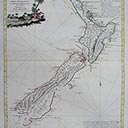
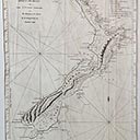
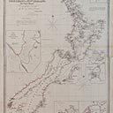
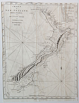
Chart of New Zealand, explored in 1769 and 1770 by Lieut: I: Cook, Commander of His Majesty's Bark Endeavor
est. $1,500 - 2,500
Chart of New Zealand, explored in 1769 and 1770 by Lieut: I: Cook, Commander of His Majesty's Bark Endeavor
Lithograph
0 x 0 cm
Inscriptions
0 x 0 cm
est. $1,500 - 2,500
Fetched $1,500
 Relative size
The first complete map of all coastal New Zealand. The chart was made during Cook's first voyage and shows the track of the Endeavour with dates and soundings. Although New Zealand had been discovered by Abel Tasman in 1642, it was Cook who discovered that it was not part of the great 'Terra Australis'. Arriving at Poverty Bay on October 7, 1769, Cook took six months to circumnavigate the islands. He sailed east of Banks Peninsula and mistook it for an island. Stewart Island is marked as a peninsula.